Advanced 3D Seismic Attributes & Neural Net Discussions
| Neural net disc.wmv | 3.3MB |
| Geophy-facies-audio.wmv | 2.7MB |
| Energy.wmv | 2.2MB |
| absorp-w-audio.wmv | 2.9MB |
| Spec decomp.wmv | 4.7MB |
Conventional Drilling Advantages
| |
Explanation of our Bright Spot Technology
The “bright spot” trend in Texas covers a swath of nine counties along the Gulf Coast of Texas. These “bright spots” occur in the Miocene, Frio, and Yegua Trends. The depth of these prospects range from 800’+/- (Miocene) to 8,000’+/-, which make all the potential prospects “shallow”, no pipe setter. That translates to low cost drilling. Most of our experience is in the Miocene, Catahoula (Basal Miocene), and Frio trends. We have been active in these trends since 1991 and started with a 66% success record, and have improved over the years to the point of a better than 87.5% success (seven successful wells out of the last eight wells drilled our past year’s exploration). In this nine county exploration area, to date, the Miocene has produced 2,488,055,342 MCF of gas and 9,502,970 barrels of oil; the Frio has produced 4,497,688,605 MCF of gas and 1,022,994,252 barrels of oil. The evidence shows this area is prolific in these trends.
Geologically, the gas sands in this area, are found in the Miocene, Frio, and Catahoula Sands. The largest reserves have been in the Frio Sands, and in particular, the 3,400 to 4,500 foot Frio Sands. However, the Basal Miocene, in particular, the Catahoula Geological sequence with depth ranging from 2500-2900 feet, has also been an excellent producer, with many wells exceeding 1.5 billion cubic feet of gas production. These sands are generally stratigraphic and rely on structural components for productivity. These sands are generally fluvial in nature and were probably the sight of an ancient delta.
The best gas accumulations usually occur in point bars, which formed during a flood stage. These generally have an aerial perspective of an ox bow. Secondary gas accumulations are found in old channel fills and splays. In our exploration area the majority of the prospects are point bars because of the stratigraphic nature of these reserves and the meandering nature of these sands. Subsurface geology is not the sole means of discovery of these reserves. 3D seismic is a much more useful tool in finding these gas reserves. The development of these prospects relied primarily upon the use of “bright spot” technology, the results of which are refined by using surrounding well control and tying this well control to the 3D seismic.
The use of “bright spot” technology has been one of the most effective tools used in the exploration for shallow gas. In the Gulf Coast of Texas, geologists-geophysicists have been very successful in utilizing seismic “bright spots”. “Bright Spots” occur seismically because of density changes in surrounding rock matrix or in some cases the presents of gas.
1) Density changes are typically due to the rock strata going from a sand/shale environment to a more limy formation. This abrupt change in density will cause a “Bright Spot”.
2) When gas in any amounts is added to a sand/shale environment the poisson ratio makes an abrupt change thus causing a “Bright Spot”.
Over the past 20 years we have successfully been able to eliminate the #1 cause through the use of modeling and advanced attribute and neuro-net analysis, but as of yet the #2 cause we are unable to determine any difference in some areas between commercial gas and non-economic gas. The best solution to this dilemma is a more in-depth study of an area, which we have stayed in our current area of exploration since 1991; giving us much better understanding and thus giving us much higher success rate. We have been using “bright spot” technology in the discovery of shallow gas reserves since 1991, and have been very successful in our exploration programs. Refining our technique through the use of computer models and finally neural net, we have been able to increase our success ratios significantly. We have set up the following criteria in picking seismic “bright spots”.
1. A weak peak followed by a sharp trough, followed by a strong peak.
2. A phasing out of the wavelet on either side of the “bright spot”.
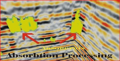
3. A frequency absorption (wash-out zone) directly below the “bright spot”.
4. Finding a tuning frequency of a gas sand in an area, through the use of spectral decomposition, in conjunction with a computer neural network (Artificial Intelligence_A.I.) and applying the results back to the proposed prospect.
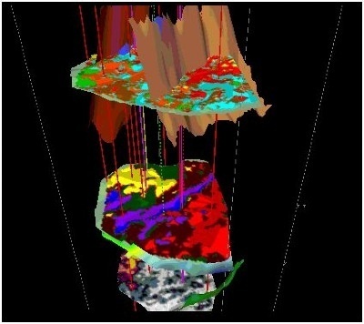
Most recently point 4 may prove to be the most useful hydrocarbon indicator we have used in prospect generation, but it is so new that we need more field trials to be certain. Our field studies so far have shown a near 100% accuracy. We refer to this newest technology as GLOW (Geophysical Low-frequency Observation on wavelet) analysis. We have found criteria three to be one of the most important and most field proven points. This absorption of the wavelet below the “bright spot” is caused by the wave front passing through a gas zone that acts as a lens. The first criterion is also the direct result of a wave front passing through a gas charged sand. The strong trough is due to a boundary between the overburden rock and a gas charged sand. The strong peak below is due to the addition of S-waves to the wave front that is primarily composed of P-waves. When passing through a gas charged sand, an S-wave component is added to the wave front. S-waves are unique in that they do not exist in gas charged sands. Thus, when the wavelet passes through a gas charged sand, the wave front is amplified. We, through our Advanced Attribute and Neural Net Technology, are able quantitatively image this Absorption (see exhibit)
Neural Network Technology
Neural networks are the most widely used artificial intelligence (AI) software by major oil companies. They are very powerful extensions to existing analysis techniques such as 3D seismic. Neural networks are non-linear optimization and information-processing tools that attempt to mimic some features of the human brain. Just like the human brain, neural networks are most suitable for pattern matching, classification, clustering, and approximation. This is done through learning and training (i.e., artificial intelligence or AI). Specifically, neural networks:
- deal with information that is inconsistent, or spurious seismic signals (noise) caused by ground motion not associated with subsurface reflectors;
- handle unforeseen situations by applying knowledge from proven oil and gas plays, and extrapolating this to new discoveries;
- deal with large amounts of input data and extract the relevant properties of that data;
and like the human brain, it quickly adjusts to new situations and actively learns by experience.
In short, neural networks help delineate potential oil and gas deposits beyond the capability of 3D seismic alone.
In working the 3D seismic data in our exploration area, virtually every successful shallow gas well can be tied to a seismic “bright spot” complimenting our criteria. By following this methodology it is my belief that we should realize an excellent success ratio.
-Nettlecombe Oil Company, Inc.